 2 months ago
57
2 months ago
57

 Getty Images
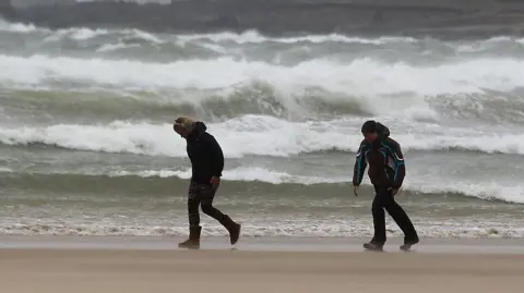
Wind gusts of up to 80mph are forecast
Scotland is braced for the worst of Storm Dave with high wind warnings in place and the possibility of snow over the Easter weekend.
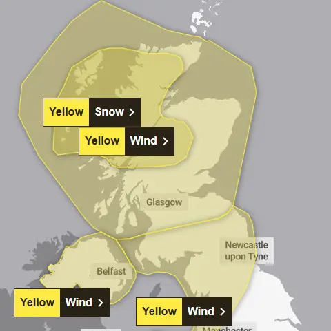
There are four separate yellow wind warnings due to take effect across the UK, with snow predicted to hit the west Highlands, Argyll and the Western Isles from 14:00.
Power firm SSEN predicts wind gusts could reach about 80mph in parts of the Western Isles and Skye - with the high winds also hitting Orkney and Shetland on Sunday.
Northern Ireland and parts of Wales and the north of England can expect windy weather until the early hours of Sunday, with forecasters warning of damage to buildings and flying debris.
It is likely both public transport and road travel will be impacted and anyone travelling should take extra care and plan ahead, the Royal Society for the Prevention of Accidents (Rospa) said.
Where and when will Storm Dave hit?
Northern Ireland will be hit first from 14:00, while southern Scotland and northern parts of Wales and England will see gusts from 17:00.
The rest of Scotland will be hit from 18:00, with all warnings expiring on Sunday - at midday at the latest.
Orkney and Shetland have a warning for Sunday until 15:00, with peak gusts of 60-70mph forecast and "slight chance" of 85mph in exposed areas.
A Met Office spokesperson said: "A rapidly deepening area of low pressure, Storm Dave, is likely to move north-eastwards close to or across north-western parts of the UK during Saturday evening and night, clearing to the North Sea by Sunday."
They added: "Peak gusts of 50-60 mph will be possible fairly widely, with 60-70 mph in more exposed locations.
"Large waves may lead to some dangerous conditions around windward coasts."
 Met Office
The Met Office has issued a number of weather warnings, including for wind and snow on Saturday
Police Scotland said people should delay their journeys if possible.
Ch Supt Scott McCarren, head of road policing, said: "Stopping distances can be at least double on wet roads compared to dry conditions, and spray can reduce driver visibility.
"HGV and bus drivers should drive with extreme caution and be aware you may be asked to park at a suitable position by the police."
He added: "If you need to travel, please drive to the conditions and take extra time for your journey."
West coast ferry operator CalMac warned that sailings could be disrupted or cancelled - some timetables have already been amended and the last ferry to Arran is earlier than usual.
Highlands and Islands Airports also said the adverse weather could impact on flights.
Scotland's weather forecast as Storm Dave sweeps in
Hills across central and the north-west of Scotland could also see sleet and snow during the weekend.
A yellow weather warning for heavy snow and blizzards has been issued for 14:00 on Saturday to 03:00 on Sunday.
A spokesperson for the Met Office said: "Outbreaks of snow will spread from the south during the afternoon, this becoming heavy at times later in the afternoon and evening, before clearing in the early hours.
"Strengthening winds will bring drifting of lying snow with the chance of blizzard conditions over the more exposed areas."
Forecasters said accumulating snow on roads would mostly be in areas above 656ft (200m), where up to 12in (30cm) was possible.
Between 2in (5cm) and 4in (10cm) is likely in low areas.
By late Sunday, the worst of the weather should have cleared.